
Which Modern Technology Actually Helps Game Management?

Last Updated: October 29, 2026
Quick Summary
Trail cameras, handheld GPS mapping and drones are the modern technologies most useful for game management, with trail cameras the usual entry point. Their value depends on matching each tool to a specific question and reviewing the data routinely through the season.
- Start by defining the decision you need information for, such as siting feeders or timing a cull.
- Mount trail cameras at knee to waist height, angled slightly downward, with vegetation cleared from the detection zone.
- Treat smartphone GPS readings as approximate and use survey-grade equipment where legal boundaries are involved.
- Review camera data at least weekly during the breeding and rearing period so predator activity can be acted on.
- Start with one or two tools tied to a clear question and expand only when the data changes a decision.
Table of Contents
- What Counts as Modern Technology in Game Management
- Trail Cameras for Wildlife Monitoring
- GPS Mapping for Game Management
- Drones for Wildlife Surveys
- Wildlife Population Monitoring and Data Analysis
- Live Operations: Using Data Through the Season
- Habitat Management and Technology Support
- Data Security, Privacy and Responsible Use
- Choosing Technology for Your Estate: Trade-offs to Weigh
- Frequently Asked Questions
What Counts as Modern Technology in Game Management
Modern game management now means far more than a rifle, a pair of binoculars and a good dog. Estates are adding digital tools that record wildlife activity, map land boundaries and show where habitat is working. Game management technology is the set of devices and software that helps a keeper observe, measure and act on what is happening across the ground. The question is not whether to adopt these tools, but which ones repay the time and money they demand.
Most estates start with the simplest kit: trail cameras, a handheld GPS and a spreadsheet. Others move on to drones, population models and live dashboards once they have a clear reason to. Many keepers find that the best results come from matching the tool to a specific question, such as where deer are feeding or whether a release pen is attracting predators.
A common mistake is buying equipment before deciding what information you actually need. Define the decision first, whether that is siting feeders or timing a cull, and the right technology becomes much easier to identify.
Trail Cameras for Wildlife Monitoring
Trail cameras are the most widely used entry point into wildlife monitoring. They are motion-triggered, weatherproof units that record stills or short video whenever an animal crosses their field of view. For a keeper, they answer practical questions about which species use a route, at what times, and in what numbers.
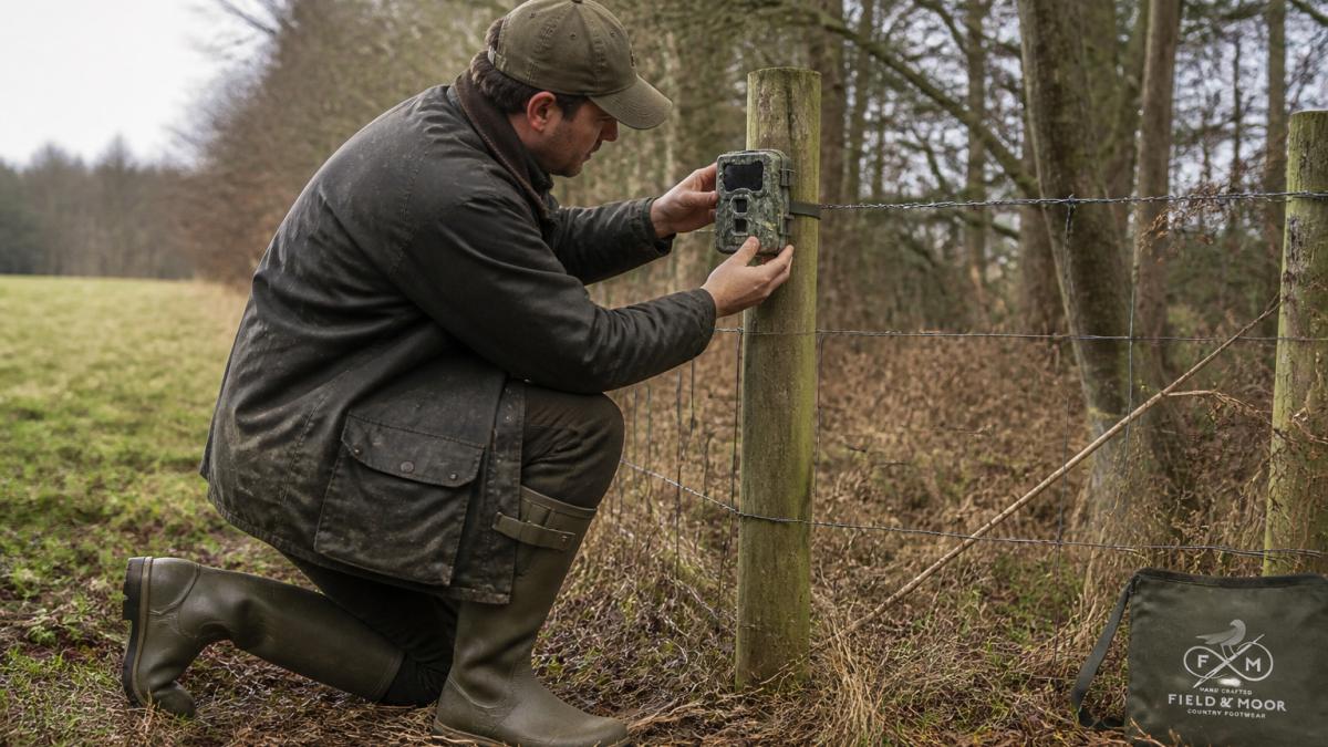
Their value depends on where they are placed. A camera covering a well-used game trail or a feeding station will generate far more useful records than one pointed at an empty clearing. Many keepers rotate cameras across the estate each season so that coverage reflects changing habitat use.
Cameras also raise ethical and practical questions. Images can capture people and vehicles, so check the position of each unit against any privacy obligations and keep memory cards and footage secure.
Placement and Settings That Produce Usable Data
Mount cameras at roughly knee to waist height, angled slightly downward, and keep the sun out of the lens. Clear vegetation from the detection zone, because grass moving in the wind triggers false records. Note the date, location and camera ID for each unit so that footage can be linked to habitat notes later.
Settings matter as much as position. Choose a short delay between triggers so repeated visits are logged without filling the card with duplicates. Set the trigger sensitivity to suit the species you are targeting, and test each camera for a day before committing it to a long deployment. Replace batteries on a schedule rather than waiting for failure, since a dead camera during a key week produces no data at all.
Camera placement and settings decide how useful the footage is, so the main points are:
| Factor | Recommended practice | Reason |
|---|---|---|
| Mounting height | Knee to waist height | Captures species and body size clearly |
| Camera angle | Slightly downward | Keeps the detection zone in view |
| Sun exposure | Keep sun out of the lens | Prevents washed-out images |
| Vegetation | Clear from detection zone | Stops wind-moving grass triggering false records |
| Test period | One day before long deployment | Confirms the unit works as set |
| Battery | Replace on a schedule | Avoids a dead camera during a key week |
GPS Mapping for Game Management
GPS mapping turns scattered observations into a spatial record of the estate. Handheld units and smartphone apps can log the coordinates of feeders, drinking points, pheasant pens and shooting stands, then plot them onto an accurate base map. Over time, this record shows how the estate is actually used rather than how it was planned.
The practical benefit is clearer boundaries and better records. A keeper can measure the area of a drive, check where a neighbouring property begins, or hand a contractor a precise map of where work should happen. Many estates keep layered maps covering habitat types, access tracks and sensitive areas such as nesting sites.
Accuracy varies with the device and tree cover, so treat smartphone readings as approximate and use survey-grade equipment where legal boundaries are involved.
Drones for Wildlife Surveys
Drones can cover ground quickly and provide an overhead view that is difficult to get any other way. They are useful for counting deer in open country, checking the condition of woodland edges and mapping water courses after heavy rain. Thermal-equipped drones can detect body heat in dense cover at dawn or dusk, which is when many species are most active.
Their use is governed by rules, and they are not suitable everywhere. Pilots must follow Civil Aviation Authority requirements, and some estates must also consider disturbance to wildlife and neighbours. Flying over protected sites may need permission from the relevant conservation body.
Watch out: a drone flown too low or too close to nesting birds or a sensitive herd can cause the disturbance the survey was meant to measure. Set flight height and timing with that in mind.
Wildlife Population Monitoring and Data Analysis
Individual tools are most valuable when their data is combined into a population picture. Camera counts, drive records, spotlight surveys and fallen-stock records can be tracked together to show trends over several seasons rather than single snapshots. Consistent methods matter more than sophisticated software, because a series of comparable counts reveals change far better than a one-off estimate.
Analysis can be as simple as a shared spreadsheet with a standard template for each survey, or as advanced as statistical models run by a specialist. Many keepers find that a regular, repeatable routine produces the most reliable decisions. The aim is to spot a falling trend early enough to act on it, not to produce precise numbers that no one uses.
Where estimates support a licence or a cull decision, record the method and the assumptions behind each figure so that others can check them.
Live Operations: Using Data Through the Season
Technology earns its keep when information flows into daily decisions rather than sitting on a memory card until the season ends. Live operations in a game management context means running the estate on a weekly and daily rhythm: camera alerts reaching a phone in the field, shared maps updated by the person who saw the change, and a single log of feeding, release and predator control activity that everyone can see. This is the management layer that most technology guides skip, and it is where the return on investment is actually realised.
Build a Season Calendar Around Data Reviews
A practical pattern is to anchor reviews to the management calendar rather than to the equipment. During the breeding and rearing period, review camera data at least weekly so that predator activity around release pens is spotted while it can still be acted on. In the weeks before a cull or a count, check that every camera and GPS unit is charged, carded and tested, because a dead unit during a key week produces no data at all. After storms or heavy rain, check feeders, pens and access routes and update the map if a track has become impassable. After any change to cover, crop or boundary, update the shared map the same week, not at the end of the season. Consistent maintenance of these digital tools ensures that predator control efforts remain both effective and compliant with current trapping ethics and regulations.
Assign Ownership, Not Just Tasks
Data that nobody owns is data nobody trusts. Name a responsible person for each stream, one for camera deployment and card collection, one for the shared map, one for the feeding and release log, and make it clear who reviews each stream and when. On a small estate one person may hold all three roles, but the roles should still be written down so that cover during leave or illness does not break the record. Keep a simple handover note so that a relief keeper knows which units are deployed where and which cards are due for collection.
Watch the Systems, Not Just the Wildlife
Technology fails quietly. Batteries fade, memory cards fill, apps update and change their menus, and a camera knocked by livestock can point at the ground for a month without anyone noticing. Build a short equipment check into the weekly routine: confirm each unit is still in place and still capturing, confirm the shared map matches what is on the ground, and confirm the log has entries for every feeding and release event. A simple traffic-light status against each unit, working, needs attention, offline, is enough to catch most failures before they cost a season's data.
Close the Loop with Measurable Outcomes
The point of live operations is to change a decision, so record what changed. If camera data showed increased predator activity at a pen and you responded, note the response and the result. If a count suggested deer were moving to a different part of the estate, note whether the feeding or culling plan changed as a result. Over two or three seasons this record becomes the estate's own evidence base, and it is far more persuasive to a landlord, a neighbour or a licensing authority than a single season's impression. Track a small number of indicators consistently, sightings per camera-night, predator visits per pen per week, feed consumed per week, and the proportion of planned reviews actually completed, rather than a long list nobody reads.
Habitat Management and Technology Support
Technology is most useful when it supports habitat work rather than replacing it. Cameras can show whether a new hedge is being used, GPS maps can record where cover crops have been sown, and population data can show whether management changes are producing results. The tools tell you what the habitat is doing, and the management decides what to do about it.
Field conditions take a toll on everything, including the footwear and clothing used to walk the estate.
Data Security, Privacy and Responsible Use
Estate data is valuable and can be sensitive. Location records of nesting birds, release pens and sporting activity, images of staff, visitors and neighbours, and the movement patterns revealed by camera footage all warrant protection. A lost phone with the estate map on it, or a cloud account without two-factor authentication, can expose information that took years to build. Responsible use is not only a legal obligation; it is part of good estate management and it protects the relationships a keeper depends on.
Know What Counts as Personal Data
Trail cameras and drones routinely capture images of people, and vehicle number plates are personal data too. Images that identify a living person can be personal data, and anyone holding them should handle them lawfully. In practice that means being clear about why footage is collected, keeping it only as long as needed, storing it securely, and being prepared to respond if someone asks what you hold about them. Official guidance on handling personal data is worth reading before deploying cameras near public rights of way or shared access routes (CCTV and video surveillance).
Practical Controls for Estate Data
Start with the basics done properly. Use a unique password for each account rather than one reused across the estate, enable two-factor authentication on cloud accounts and shared drives, and limit access to the people who genuinely need it. Keep an inventory of devices, cameras, handheld GPS units, drones, phones and tablets, with who holds each one and what data it stores. Encrypt laptops and phones that hold the estate map, and set them to lock automatically. Keep backups of survey data in at least two places, so that a lost or failed device does not erase years of records.
When a device is retired or a memory card is no longer needed, wipe it properly rather than deleting files. Memory cards and old phones are a common route for data to leave an estate unnoticed.
Footage, Retention and Access Requests
Decide in advance how long footage is kept and stick to it. A common pattern is to review and delete routine camera footage after a set period unless it is needed for a specific purpose such as a wildlife record, an incident or a legal matter. Store footage in a way that lets you find and delete it, rather than leaving it scattered across cards and phones. If someone asks for footage of themselves, or asks what data the estate holds about them, have a named person responsible for responding and a simple process for doing so within the time the law allows.
Be clear with staff and visitors about where monitoring takes place. A short written notice at the estate office and a line in staff induction are usually enough, and they prevent the suspicion that hidden monitoring creates.
Security Beyond Privacy
Account security matters as much as privacy. Shared logins, weak passwords and unpatched apps are the most common ways estate accounts are compromised, and a compromised account can expose the location of release pens or nesting sites. Keep software and apps updated, remove access promptly when someone leaves, and avoid sharing sensitive locations on social media or in messaging groups that include people outside the estate team. If the estate holds information that would be damaging in the wrong hands, treat it as you would any other valuable asset: with a named owner, a clear policy and a routine check.
Choosing Technology for Your Estate: Trade-offs to Weigh
No single tool suits every estate. A small holding may get more from a few trail cameras and a shared map than from a drone, while a large estate with varied terrain may justify a broader mix. Weigh the cost of purchase against the time needed to maintain equipment, process data and train staff, since an unused system is an expensive one.
Staffing shapes these choices. A dedicated game keeper can run a more demanding set of tools than a landowner who manages the ground part-time.
We recommend starting with one or two tools tied to a clear question, reviewing results after a full season, and expanding only when the data is changing a decision. That approach keeps spending proportionate and makes the value of each investment easy to judge.
Frequently Asked Questions
What technology is used in modern game management?
Modern game management commonly combines trail cameras, GPS and mapping software, drones for surveys, and population records kept in digital systems. Trail cameras record activity at set locations, GPS tools help plot feeding areas, release pens, boundaries and habitat, and drones can cover ground quickly for counts. Records from all of these can be stored and compared over seasons. Each tool answers a different question, so most estates use a small combination rather than relying on one device. Check current guidance from relevant conservation bodies before relying on any method for a specific species or site.
How do trail cameras help with game management?
Trail cameras show which species use a site, when they are active, and roughly how many visit. Placing cameras at feeders, field edges and game crossings gives a record of movement without disturbing animals. Many keepers review images weekly and log them against weather and feeding times. The main limitation is that a camera only sees its field of view, so results are indicative rather than a full census. Position cameras consistently and keep dates and locations recorded so that comparisons between seasons are meaningful.
Can drones be used for wildlife monitoring?
Drones can support wildlife surveys by covering open ground faster than walking, particularly for counting birds on water or deer in open fields. Thermal sensors can help locate animals in low light, although detection depends on weather, cover and the sensor used. Flights must follow the applicable aviation rules, including registration and the restrictions that apply near people, livestock and protected sites. Drones add value when they are part of a planned survey method rather than an occasional check.
How is data used to manage wildlife populations?
Keepers and land managers use counts, camera records and habitat notes to estimate population trends over time. Consistent methods, repeated at the same times of year, matter more than any single figure. Recording location, date, species and conditions allows changes in numbers to be compared with habitat work, predator control or feeding. Data should be reviewed alongside advice from wildlife professionals before decisions about culling, release or habitat change are made.
